GPS TECHNOLOGY is being used to track fine-scale feral deer movement patterns, habitat use and home range behaviour within the Port Macquarie-Hastings region.
The program will be carried out by the Centre for Invasive Species Solutions (CISS) and staff from North Coast Local Land Services (LLS), with support from Port Macquarie Hastings Council.
It will involve the placement of clover traps in selected locations where feral deer activity is known to be high.
Captured animals will be safely sedated by trained personnel, fitted with purpose-designed GPS collars and then
released.
The collars will transmit regular location data, enabling land management agencies to analyse deer behaviour, home range characteristics and how deer move through the landscape.
CISS Lead Researcher for Feral Animal Projects, Darren Marshall said, “This is an exciting project for CISS as it transfers our acknowledged expertise in GPS collaring for feral pigs to deer for the first time.
“The project builds on Rusa deer management undertaken in the region over many years.
“But what makes it special – and an Australian first – is a higher incidence of GPS data points from each animal.”
The collars will transmit nearly 300 datapoints each day.
“[This will] reveal new insights into individual deer behaviour and provide rich data for our movement analysis work with the NSW Department of Primary Industries and Regional Development,” Mr Marshall said.
“This analysis will not only help inform local management approaches but also provide key information on how deer interact with the community and the built environment.
“Critically, for example, where and when they’re crossing roads, as well as other interactions impacting residents.”
North Coast LLS has been implementing the Hastings Feral Deer Management Plan through coordinated control programs for the last five years.
“This program will give us valuable information about how feral deer move through the landscape and where activity is highest,” North Coast Local Land Services General Manager Alison Bowman said.
“That data will help guide targeted and coordinated management across both public and private land.”
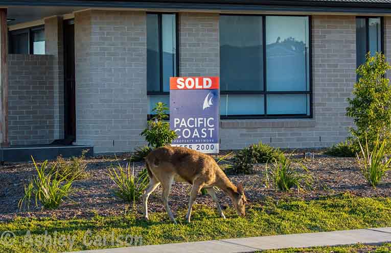
Port Macquarie-Hastings Council General Manager Robert Fish said feral deer are an increasing concern for the region, impacting native vegetation, farmland and road safety.
“Working with North Coast Local Land Services on this GPS tracking program will help us better understand where deer are moving and guide more effective management across the region,” he said.
Reporting feral deer sightings
The DeerScan app allows Australians to report sightings and contribute data on deer movement and activity during breeding season, which peaks from late autumn into early winter.
Dr Jane McKenzie, National Feral Deer Management Coordinator, said rapidly growing deer populations are endangering public safety on roads and rail and placing increasing pressure on natural environments and farming communities.
“This is the best time to spot deer and signs of activity, such as rubbing their antlers on shrubs and trees,” Dr McKenzie said.
“It’s important to report sightings and signs of live and dead deer through the app, particularly in areas with low deer populations where they can otherwise go unnoticed.”